


| Version 5 (modified by hettrich, 5 years ago) (diff) |
|---|
WP-S5.2: Acquisition of open-source data and automatic generation of surface input parameters
Goals of the project:
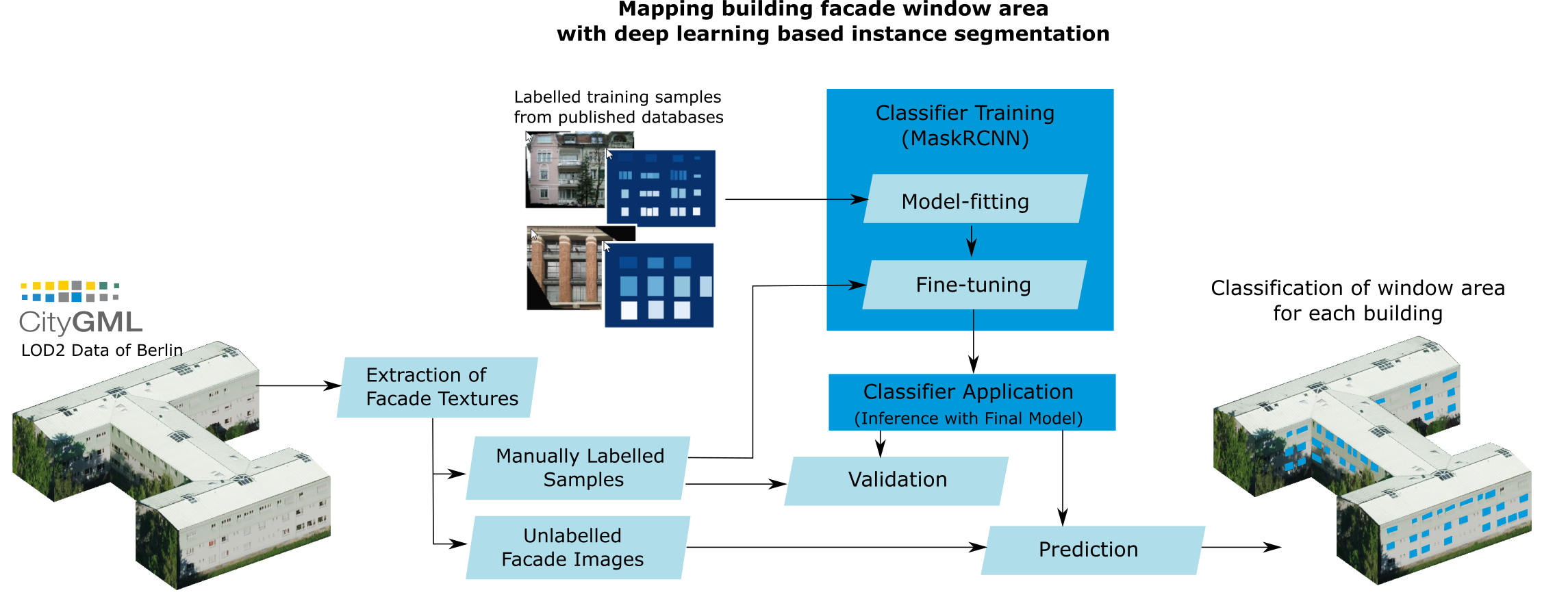
WP-S5.2 focuses on the surface input parameters for PALM-4U and aims to improve these. First, open-source data sets are collected that can be used to derive the input parameters in an automated way. For this, free data sets are selected that are at least available Germany-wide, and where possible even at European or global scale. Second, the possibilities of generating new spatial input parameters are investigated to support new simulations in PALM-4U. Possible input parameters are window fraction, façade colour or improved 3D descriptions of trees and buildings, e.g. by using LiDAR data.
Project Tasks:
The work in MOSAIK Phase 1 showed the importance of automated generation of surface input parameters, as well as the provision of open-source data. As not all municipalities have the same data available at the same level of detail, it is useful to have a base layer available that consistently provides a minimum amount of spatial input parameters and which can be supplementary, if necessary, with local parameters. This basic data-set should only consist of open-source data, if possible, to allow their use for everyone, who intends to test PALM-4U. Many open-source data not only exist for Germany, but also for Europe and globally. Therefore, it would allow the transferability of PALM-4U to cities outside of Germany.
Additionally to the need for a basic data-set, the demand for further spatial input parameters, which will be developed in this work package, has been identified during the development of PALM in MOSAIK-1. Therefore, the goal of work package WP-S5.2 is to improve the surface input parameters for PALM-4U in two different ways:
1) Development of an open-source surface data set(s) from which the input parameters can be derived automatically.
2) Development of methods to integrate new high-resolution input data.

Figure 1: Examples of input parameter (parts of) the study area of Berlin, Germany, for PALM-4U. Created by DLR. Data sources: FIS Broker Berlin (LiDAR, CIR imagery, CityGML), Open Street Map (OSM) and SRTM
Project structure
This project is conducted at the German Aerospace Centre in Oberpfaffenhofen.
PI: Dr. Wieke Heldens
Deliverables:
Progress so far:
References
Heldens, Maronga, Zeidler, Kanani-Sühring, Hanke, Esch (2019): Remote sensing-supported generation of surface descriptors for a highly detailed urban climate model. Joint Remote Sensing Event 22-24 May, 2019, Vannes, France.
Masson, Heldens, Bocher, Bonhomme, Bucher et al. (2020): City-descriptive input data for urban climate models: Model requirements, data sources and challenges. Urban Climate. Vol. 31, 100536, doi: 10.1016/j.uclim.2019.100536.
Heldens, Zeidler, Pavlik, Burmeister, Kanani-Sühring, Maronga, Esch (submitted): Geospatial input data for the PALM model system 6.0: model requirements, data sources, and processing. Submitted to Geoscientific Model Development.
Contact:
Dr. Wieke Heldens Deutsches Zentrum für Luft u. Raumfahrt e.V. (DLR) Earth Observation Center (EOC), Deutsches Fernerkundungsdatenzentrum (DFD) Abt. Dynamik der Landoberfläche, Team Smart Cities und Raumentwicklung Oberpfaffenhofen, Deutschland
Attachments (2)
-
WP-S52-figure1.png
(1.2 MB) -
added by hettrich 5 years ago.
Figure 1
- WP-S52-figure2.png (600.2 KB) - added by hettrich 4 years ago.
Download all attachments as: .zip
Download in other formats:
Powered by Trac 1.0.5
By Edgewall Software.
Visit the Trac open source project at
http://trac.edgewall.org/