
| Version 11 (modified by sward, 7 years ago) (diff) |
|---|
Multi Agent System (MAS)
The embedded Multi Agent System (MAS) allows for the modeling of pedestrian movement in complex (urban) terrain. The following text provides an overview of the model's functionality as well as underlying concepts. This will cover the topics of creating a visibility graph, pathfinding, and Social Forces for collision avoidance.
For a list of input parameters, see agent_pararmeters.
Navigation
This section contains information concerning agent navigation. This includes preprocessing and online steps .
Visibility graph
Prior to a simulation using the MAS navigation information for the agents must be preprocessed. The result is a navigation mesh (visibility graph) that agents can use to find their way around obstacles toward their target.
Concept
For agents to be able to find a path through an area containing obstacles (such as a city) some sort of graph is needed on which pathfinding can be performed. Such a graph consists of nodes that indicate physical locations and connections between these nodes annotated with a cost to travel between the two nodes.
The concept used here is called "visibility graph". It hinges on the idea that pedestrians use outer corners of obstacles to navigate. All spaces that pedestrians will not or cannot cross, such as buildings, trees, certain types of streets, etc are considered obstacles. The agent will walk toward the next visible corner on their way to their final target, make a turn, and walk toward the next corner. Thus, the nodes are the obstacle corners and a connection is established between two nodes if they are in view of each other and given the cost of the direct distance between the two.
To produce this data,
1) the PALM building topographhy is converted to polygons (one per obstacle) containing all convex and cocave corners as vertices.
2) The polygon data is simplified using the Douglas-Peucker algorithm (Hershberger and Snoeyink, 1994). To adjust the rate of simplification, see tolerance_dp.
3) All remaining convex polygon vertices are added to the graph as nodes.
4) Connections are established between each pair of nodes that are visible by each other. The associated cost is set to the direct distance.
5) The polygon and graph data is output to a Fortran binary file that can be read by PALM.
Creating the visibility graph
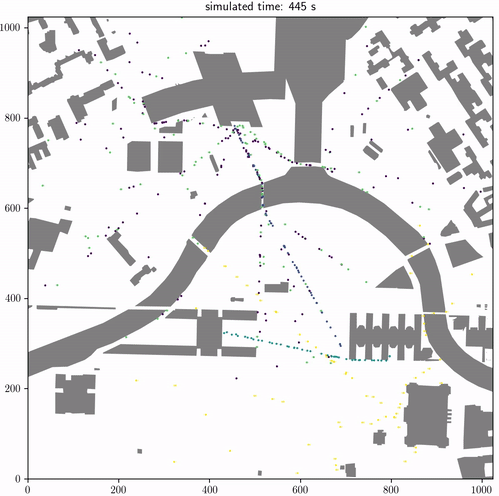
A tool separate from PALM (Agent Preprocessing Tool for PALM - APT-P) has been developed to calculate the visibility graph. It is a standalone Fortran program (find it at UTIL/agent_preprocessing/agent_preprocessing.f90).
To use it,
1) navigate to the INPUT-folder of your JOB.
2) Make sure your Input folder contains the relevant topography information in either an ASCII- or NetCDF-file (see here).
3) Make sure your Input folder contains the _p3d-file. In it, if necessary, specify the namelist &prepro_par with the parameters flag_2d, internal_buildings and tolerance_dp.
4) Execute the APT-P by typing
agent_preprocessing
This will create a file <job_identifier>_nav. This is a Fortran binary file that contains the polygon and visibility graph data and will be read by PALM during the simulation. As long as the area and resulution of the model domain do not change this file can be reused.
Pathfinding
During the simulation each agent receives target coordinates (see at_x and at_y). Each agent must then find a path from its current position to its target using the visibility graph. This is accomplished using the A*-algorithm which is a well-known fast pathfinding algorithm (click here for a thorough explanation). For this,
Each agent calculates the direction toward its next intermittet target during each agent time step. It will accelerate toward those coordinates. Once the agent has come close enough (dist_to_int_target) to them, the next intermittent target is chosen. When the final target is reached, the agent is deleted.
|
|

Social Forces
Agent movement and close-range interaction is implemented using a modified Social Force Model. The implementation uses concepts from the original Social Force Model (Helbing, 1995) and an extension of it for close-rage collision prediction and avoidance (Karamouzas et. al, 2014).
The Social Forces approach is based on the idea that pedestrian movement is results from forces exerted on the pedestrian by its surroundings and goals. These forces can be either repulsive or attractive. Repulsive forces are associated with obstacles such as buildings, trees or other pedestrians. The current goal of each pedestrian exerts an attractive force on it. The resulting force on a pedestrian α is the sum of all attractive and repulsive forces,

The forces considered here are repulsion by obstacles and other pedestrians as well as the acceleration term driving the pedestrian toward its target.
The repulsion by an obstacle B is defined as

with the repulsive potential

In the MAS, U0 is repuls_wall and RB is sigma_rep_wall.
The repulsion by another pedestrian β is defined as

with the repulsive potential

In the MAS, V0 is repuls_agent and Rβ is sigma_rep_agent. This agent repulsive force is only used if α and β are already colliding (i.e. two circles with centers at the respective agents' position with radius radius_agent are intersecting). Otherwise, a collision avoidance force according to (Karamouzas et. al, 2014) is calculated:

Here, τ is the time until, given the current trajectory, a collision between the two pedestrians would occur, τ0 = 3 s and k is a constant to sets the units with a value of 1.5 m2 kg.
The acceleration force

describes the tendency of a pedestrian to accelerate toward its target. Here, τα is a relaxation time (tau_accel_agent) that describes how quickly the pedestrian approaches v0 its desired walking speed with the direction to its current target, e.
The pedestrian's walking speed is given by

with a simple Euler-forward method used for time-integration.
L, u∗ as well as

NAMELIST group name: prepro_par
| Parameter Name | FORTRAN Type | Default Value | Explanation |
|---|---|---|---|
flag_2d | L | .F. |
Flag to force usage of 2d-buildings. |
internal_buildings | L | .F. |
Flag to control usage of buildings within courtyards. |
tolerance_dp | R * 3 |
1.41, |
Tolerance for simplification of building polygons during preprocessing. |
References
- Helbing, D., Molnar, P. (1995). Social force model for pedestrian dynamics. Physical review E, 51(5), 4282. doi
- Hershberger, J., Snoeyink, J. 1994. An O(nlogn) implementation of the Douglas-Peucker algorithm for line simplification. SCG '94 Proceedings of the tenth annual symposium on Computational geometry. 383-384. doi
- Karamouzas, I., Skinner, B., Guy, S.J. 2014. Universal Power Law Governing Pedestrian Interactions. Pyhsical Review Letters, 113, 238701. doi
Attachments (11)
- pathfinding_berlin.gif (6.1 MB) - added by sward 7 years ago.
-
color_scheme.png
(10.0 KB) -
added by sward 7 years ago.
Color scheme for the buttons
-
lm_mono_caps_10_font.zip
(41.5 KB) -
added by sward 7 years ago.
Caps font for buttons
- button_template.pptx (64.4 KB) - added by sward 7 years ago.
- button_a_star.png (50.0 KB) - added by sward 7 years ago.
- button_code_structure.png (63.9 KB) - added by sward 7 years ago.
- button_ex_setup.png (54.5 KB) - added by sward 7 years ago.
- button_input.png (52.8 KB) - added by sward 7 years ago.
- button_output.png (63.1 KB) - added by sward 7 years ago.
- button_prepro.png (64.9 KB) - added by sward 7 years ago.
- button_social_force.png (76.3 KB) - added by sward 7 years ago.